Physical & Shipping Address
SNARL
1016 Mt. Morrison Road
Mammoth Lakes, CA 93546
Driving to SNARL
TO SNARL FROM THE NORTH
Take US 395 south toward Mammoth Lakes and Bishop, CA. Do not take the Mammoth Lakes turnoff (Highway 203) off 395. As you pass the Mammoth turnoff note the reading on your odometer. Proceed another 5.5 miles and you will see a small green church on the left side of the highway. Stay on 395 one-half (0.5) mile past the church and turn RIGHT on Mt. Morrison Rd. Proceed to the end of Mt. Morrison Rd. (ca. 1 mile) and you will be at SNARL.
TO SNARL FROM THE SOUTH
Take US 395 north to Bishop, CA. As you head north out of Bishop look for a Shell Gas station at the junction of US 395 and Highway 6. Note the reading on your odometer and proceed north on 395. At 31.3 miles you will pass a turnoff signed “Crowley Lake Drive/Long Valley”. The turn to SNARL, Mt. Morrison Rd., is the next turn on the LEFT, at 32.5 miles. Proceed to the end of Mt. Morrison Rd. (ca. 1 mile) and you will be at SNARL. If you reach a small green church on US395 at the Benton Crossing Road you have gone exactly 0.5 mile too far on 395. Make a u-turn and proceed 0.5 mile south of the church to Mt. Morrison Road.
SNARL Maps
Click here to download a pdf of the SNARL Site and Campus Map
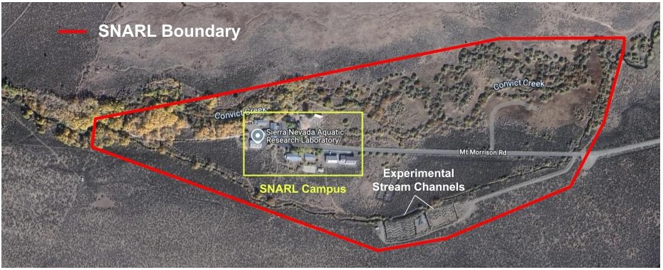
SNARL Site Map

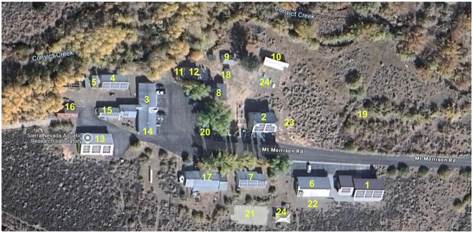
SNARL Campus Map

Map Key
Classroom/Labs
- 1 – Page Center
- 2 – Headquarters
- 3 – Laboratory
- 4 – Fish House
- 5 – Animal House
Housing
- 6- Sage Dormitory
- 7 – Cottonwood House
- 8 – Meadow House
- 9 – Creek House
- 10 – Willow House
- 11- Aspen House
- 12 -Lupine House
Other
- 13- Garage
- 14 – Shop
- 15 – Wood Shop
- 16 – Storage
- 17 – Director’s House
- 18- Bath Shack
- 19 -Camping Area
Recreation
- 20- Basketball Hoop
- 21 – Volleyball Court
- 22 – Bocce Court
- 23 – Horseshoe Pit
- 24 – Shade structures
Regional Map

